

MAPS


Flood Zone Designations
No matter which city or state you live in, you live in a flood zone. Some locations are more likely to experience a flood. These locations are known as Special Flood Hazard Areas.
This map will show you the different flood zones located within the City of Bay St. Louis.
Click on the image to enlarge it. You will then be able to zoom and navigate on the map.

What is my Base Flood Elevation?
If you live in a Special Flood Hazard Area (SFHA), you are required to build above the Base Flood Elevation (BFE). Using this map, you will be able to zoom to your property and determine which flood zone you live in, and the BFE for that particular zone and location of your property.
If you live in an AE or VE zone, you must be elevated. If you live in an X zone, you are not required to elevate nor is there a required BFE.
Click on the image to enlarge it. You will then be able to zoom and navigate on the map.
Protecting Your Home With Flood Insurance
Are you protected?
Water, Water Everywhere!
Bay St. Louis is a waterlovers dream. From its open beach front on the Mississippi Sound to the protected area of the Bay of St. Louis. From the mouth of the Jourdan River to its miles of canals and other waterways. Bay St. Louis is comprised of 49% water.
With water in such a large amount of the City, there is always a chance of flooding. This map will illustrate our waterbody area.
Click on the image to enlarge it. You will then be able to navigate on the map.

Wetlands Designations
With over 3,376 acres of marsh and wetlands within the City limits, many properties are affected by this. Additional regulations may apply to these properties and owners should be aware of where their property lies.
Click on the image to enlarge it. You will then be able to navigate on the map.

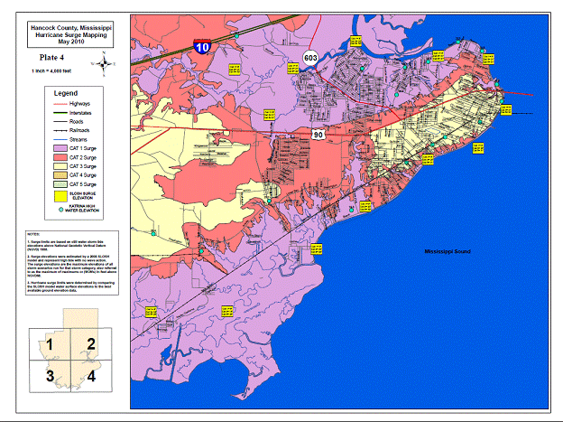
Storm Surge
Along the coast, storm surge is often the greatest threat to life and property from a hurricane. In the past, large death tolls have resulted from the rise of the ocean associated with many of the major hurricanes that have made landfall. Hurricane Katrina (2005) is a prime example of the damage and devastation that can be caused by surge.
To the left you will find a Hurricane Surge Map which will show you the depth of water in certain areas based on the severity of the hurricane hitting this area.
Click on the image to enlarge it. You will then be able to navigate on the map.
Follow this link to the National Weather Service for more information about storm surge and how it can affect all of us.
Contour Maps
A contour map is also called a topographic map. Contour maps are highly detailed maps that show natural and man-made features. The main feature that differentiates contour maps from other maps is the demarcation of elevation through the use of contour lines. Contour lines indicate the elevation of features such as mountains and and depths of items such as lakes.
Using the grid to the right, locate the approximate area of your property location. Bay St. Louis maps available are:
-
F9, F10, F11
-
G8, G9, G10, G11
-
H8, H9
Once you have located your approximate grid location, click the image to the right. A document with links to the map you are needing will load. Click the appropriate grid link and your map will appear. These contour maps will give you a general contour of the approximate height or elevation above sealevel of your property. For a more accurate elevation, you will need to have an elevation certificate done for your property. Click this Elevation Certificates link for more information.

Drainage System Maintenance
Bay St. Louis maintains a storm drainage system throughout the city. In order for the drainage system to operate effieciently, the ditches, streams, and channels must be kept as clean as possible. Debris, including leaves and grass clippings, may obstruct the flow of water and cause overflow onto the streets and yards. The City's Stormwater Management Ordinance makes it illegal to take any action that will impede the flow of water in ditches and waterways. Before making any changes to the existing drainage of your property, please discuss your plans with the City's Public Works Department. If you know of any action affecting the drainage system that is being done without the required permit, any illegal dumping of debis into any ditches, or of a nuisance situation, please report it to the Public Works Dept. located at 688 Hwy 90, inside of City Hall, or call 228-467-5505. You can also report the issue online at BSL Connected.
For Main Drain locations, click on the image to enlarge it. You will then be able to navigate on the map.

Coastal Flood Exposure Mapper
Are you exposed to coastal flooding? Created by the National Oceanic and Atmospheric Administration (NOAA), this interactive mapping product will show where people, places, and natural resources are exposed to coastal flooding. Users can select their geography and create a collection of maps that can be downloaded or shared online.
To find out more and to use the Coastal Flood Exposure Mapper, click the image to the left.
